The TRACK cruises have helped to quantify the ACC transport through the Fawn Trough passage and its variabilty, and to determine the exchanges between circumpolar waters on both sides of the Plateau.
Transport Across the Kerguelen Plateau
by Y.H. Park, F.Vivier*, H.Sekma(a) and F. Roquet (b)
* Corresponding author : Frédéric Vivier
(a) : LOCEAN-IPSL, France
(b) : MISU Stockholm University, Sweden
Owing to its large meridional extent (about 18° in latitude) and relatively shallow depths, the Kerguelen Plateau constitutes a major barrier to the Antarctic Circumpolar Current (ACC) in the Indian sector of the Southern Ocean, except in the deep passage of the Fawn Trough (56°S, 2650m) where a major pathway for the ACC has been recently evidenced south of the Polar Front (PF) from elephant seals hydrographic observations by Roquet et al., 2009a. This branch represents about 20% of the total transport of the ACC in a 50km-width vein.
However, systematic velocity and hydrographic measurements had never been carried out in the Fawn Trough, which appears as a key region for exchanges between waters from the Enderby basin and from the Australian-Antarctica basin. In this context, the TRACK project aimed at improving the knowledge of the dynamics and physical processes in this part of the Southern Ocean. Specific objectives of the TRACK cruises were in particular to quantify the ACC transport through the Fawn Trough passage and its variabilty, and to determine the exchanges between circumpolar waters on both sides of the Plateau. Searching for evidence of climate-related changes in the properties of Antarctic bottom waters to the East Kerguelen Plateau was another goal of this program.
This project was a French contribution to the IPY (International Polar Year) activities, and the only contribution in the Indian sector of the Southern Ocean. TRACK has been financially supported by the CNES, CNRS/INSU, GMMC/IFREMER and IPEV.
Scientific Interest
The Kerguelen Plateau is a major barrier to the Antarctic Circumpolar Current (ACC) in the Indian sector of the Southern Ocean. Previous work showed that most of the ACC transport (about 100 Sv) is deflected to the north of the Kerguelen Islands (Park et al., 1993), which implies that a substantial remainder (about 50 Sv) has to cross the plateau through two deep passages : the Fawn Trough (56°S, 2650 m) in the middle part, and the Princess Elizabeth Trough (64°S, 3650 m) close to Antarctica.
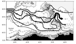
Figure 1 : Scheme of circulation deduced from the elephant seals data analysis for year 2004 combined with others historical and satellite data (from Roquet et al., 2009)
Using two hydrographic WOCE sections (I8 and I9), McCartney and Donohue (2007) suggested a transport of about 40 Sv across the Fawn Trough. Yet, this estimation was only indirect, because the two WOCE sections did not cross optimally the Fawn Trough and Princess Elisabeth Trough areas. These authors also suggested a powerful Australian-Antarctic cyclonic gyre with an unprecedented transport (~100 Sv) in this basin, while the traditional view barely mentioned the possibility of such a subpolar gyre. This gyre is associated with a powerful western boundary current strongly concentrated along the eastern flank of the southern Kerguelen Plateau.
The analysis of hydrographic data collected by instrumented elephant seals has recently confirmed (fig.1) the existence of a strong northeastward current across the Fawn Trough (Roquet et al., 2009a). However, no systematic current and hydrographic measurements had been done in the Fawn Trough. In this context, the first objective of TRACK missions was to quantify the ACC transport across the Fawn Trough, through dedicated in-situ observations. This project also aimed at testing the ability of satellite altimetry to monitor the variability of the transport of the Fawn Trough current.
Data and Methodology
Hydrographic and direct current measurements were made in the Fawn Trough area during the two legs of the TRACK project : TRACK-1 in February-March 2009 and TRACK-2 in January-February 2010. on board R/V Marion Dufresne II.
The field program also included a 1-year-long deployment of three mooring-lines of current meters across the passage, and the deployment of 12 ARGO floats.
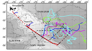
Figure 2 : Map of TRACK cruises, showing leg 1 (Feb-March 2009, black dots) and leg 2 (Jan-Feb 2010, red dots). The trajectories of ARGO floats deployed during TRACK are also shown. The thick red line indicates the stations used to plot the properties across the Fawn Trough in figure 3.
During TRACK1, 60 CTD-O2 casts have been performed, along 7 sections (fig. 2, black dots). TRACK2 has been designed to complement efficiently the first leg, redoing the sections crossing the Fawn Trough and the Deep Western Boundary Current. A transect between Heard and Kerguelen Islands has also been added. Finally, 57 casts have been completed during TRACK2 (fig. 2, red dots). For each cast, direct current measurements have been performed simultaneously using two LADCPs and the Marion Dufresne SADCP.
A total of 12 ARGO floats have been deployed in the cruise area to improve the hydrographic sampling. During TRACK1, 5 PROVOR and 2 ARVOR have been deployed around the Fawn Trough. During TRACK2, 5 additional PROVOR have been deployed. A total of 717 profiles were logged on the 15th of February 2010, including more than 200 profiles in the TRACK cruise area. A delayed-mode procedure based on comparison of deep T/S correlations between the different ARGO floats and the TRACK data showed an overall satisfying quality of ARGO data, with salinity accuracy within the standard range ±0.01 psu.
Results
Some results presented here are based on hydrographic and current measurements obtained during the two surveys of TRACK-1 and TRACK-2 and Jason-2 satellite altimeter data.
Hydrography and Transport across the Fawn Trough
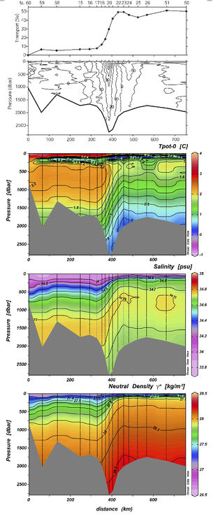
The Fawn Trough section sampled during TRACK1 is presented in fig. 3. This section clearly shows the powerful and deep- reaching 50-km wide jet (stations 17-22), associated with a 43 Sv transport according to LADCPs (Park et al., 2009). A strong baroclinic structure is observed in the temperature and salinity fields. Consequently, velocities are largest at the surface (up to 70 cm/s), then decreasing gradually to a yet non-negligible 15 cm/s bottom velocity (2600 m).
The two hydrographic markers of the Fawn Trough current proposed by Roquet et al. (2009a) are well observed in this section : the crossing of the 0oC isotherm in the subsurface minimum temperature layer, and of the 2oC isotherm in the deep maximum temperature layer.
The coldest and freshest bottom water is not observed at the deepest part of the Fawn Trough sill, but further south along the southern flank of the sill (station 23). This bottom water, carried northward by the Deep Western Boundary Current, is meandering westward across the Fawn Trough section, before returning eastward and then southward in the Australian-Antarctic Basin.
A 6 Sv branch is also detected just south of Heard Islands, which is thought to be the main pathway of water masses flowing over the shallow Northern Kerguelen Plateau (Park et al., 2008).
Figure 3 : Properties across the Fawn Trough (see thick red line in Figure 1 for casts position), as measured during the first leg of TRACK. From top to bottom, cumulative transport (Sv), LADCP speeds (cm/s), potential temperature (oC), salinity (PSU) and neutral density (kg.m-3). The Fawn Trough current is clearly seen between stations 18 and 22 as an intense jet associated with enhanced meridional gradients of hydrographic properties. Adapted from Park et al. (2009) and Roquet (2009b).
ARGO deployments
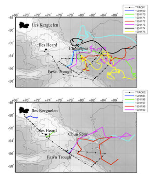
The trajectory of ARGO floats revealed two interesting features of the fine-scale circulation between the Fawn Trough and the Chun Spur (Figure 4). Firstly, it could be clearly seen that the Chun Spur blocks efficiently most of the circulation, inducing a southward deflection of the flow along its western edge. Only a rather small surface flow is allowed around 53oS, 78oE. We can note the most spectacular trajectory of float 1901171 which bypassed the Chun Spur on its south, before going north on its edge and following north-east. Secondly, 3 ARGO floats remain still during several months in a limited area lying at the centre of the circle formed by the cyclonic trajectory of the Fawn Trough current (54oS, 80oE), associated with subpolar waters carried by the Deep Western Boundary Current (see also Figure 4).
Figure 4 : Trajectories of ARGO float deployed during TRACK-1 (top) and TRACK-2 (bottom).
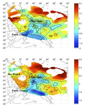
The fine structure of the circulation around the Fawn Trough is confirmed by the hydrological properties maps (fig.5). The Fawn Trough current is clearly identified by temperature gradients in the two spatial maps (T-min : 0o-0.5oC, T-max : 2o-2.2oC). The Chun Spur blocking the circulation is also observed, showing in addition that the blocking is much efficient at depth than at surface. The shallowest waters (T-min) seem to be able to pass at the north of the Chun Spur, whereas all deeper waters (T-max) are deviated south.
Cold waters are clearly identified both for T-min and T-max at the east edge of the south of the plateau, tracking the DWBC trajectory. This cold current hits the Fawn Trough current, confirming the observations of Roquet and al. (2009) measured by elephant seals. Those cold waters have a cyclonic trajecotory around the Chun Spur, before going into the Australian- Antarctica basin towards the south-east direction, where a strong mesoscale turbulence mix them with neighbouring warmest water masses.
Those observations clearly show the importance of the topography in the circulation near the the Kerguelen plateau favouring the convergence and mixing of different water masses and making the Fawn Trough a key region for the antarctic circumpolar water masses transformation.
Figure 5 : Maps of the temperature (°C) (a)- at the heart of the minimum of subsurface temperature (T-min, env. 100-m of depth) associated with cold waters formed in winter , and (b)- at the heart of the layer of the maximum of temperature ( T-max) situated near 400-m of depth.
Heat transport across the Fawn Trough
In the framework of her PhD work, H. Sekma has studied the mechanisms transporting heat across the Southern Flank of the ACC, using the set of moored current meter data obtained in the Fawn Trough (Sekma et al., 2013). The time series of velocity and temperature over the year 2009 are only the second such dataset collected in the Southern ACC Front (SACCF) and the first over the Kerguelen Plateau. The long standing belief stipulates that the poleward heat flux across the Antarctic Circumpolar Current (ACC) is mainly due to mesoscale transient eddies, and the cross-stream heat flux by time-mean flow is insignificant. This belief has recently been challenged by several numerical modelling studies which stress the importance of mean flow for the meridional heat flux in the Southern Ocean, south of 60 °S.
Sekma et al. (2013) studied the variability and vertical structure of the southern ACC front at the Fawn Trough site. The structure across the SACCF was found to be non-equivalent barotropic and generating significant bottom upwelling over the Fawn Trough. The eddy heat flux in this southern part of the ACC was found negligible, while that due to the mean flow was overwhelming by two orders of magnitude. These results suggest a new mechanism of the cross-stream poleward heat flux by time-mean flow across the southern ACC front. This is due to the unusual anticlockwise turning of currents with decreasing depth, which is associated with significant bottom upwelling engendered by strong bottom currents flowing over the sloping topography of the trough. It was concluded that the non-equivalent barotropic structure of the mean flow found in several topographically constricted passages could accomplish the needed poleward heat transport.
Variability of the Fawn Trough Current
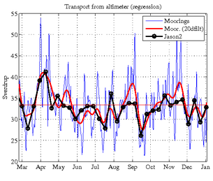
A time series of the volume transport across the Fawn Trough estimated from objective mapping of moored current meter observations features a mean transport of 34 Sv (possibly biased low by at most 5 Sv) and a variability of 6 Sv RMS, consistent with LADCP estimates obtained during TRACK1 and TRACK 2 (Vivier et al 2013). Moorings were located underneath Jason 2 ground track 94. The extent to which the transport can be directly monitored from along-track satellite altimeter data was assessed. This would enable to study the variability of the current from a now 20-year long satellite archive. While a canonical method previously applied to the Malvinas current gives unconvincing results, an ad-hoc approach is developed which yields an estimate well correlated (0.8) with in situ transport during the one year period of observations (Figure 6). The ability to reconstruct the flow from a limited set of moored instruments as well as from altimeter-derived surface geostrophic velocity is further assessed from synthetic data extracted from a high-resolution peri-antarctic regional simulation.
Figure 6 : Transport of the Fawn Trough current estimated from Jason 2 altimeter data along track 94 (black line) from March 2009 to January 2010 superimposed on daily transport from TRACK current meter moorings (blue) and low-passed filtered in situ transport with a cut-off period of 20 days (red). Units in Sv. Adapted from Vivier et al 2013.
References
- McCartney, M. S. and K. A. Donohue, 2007: A deep cyclonic gyre in the Australian-Antarctic Basin, Prog. Oceanogr., 75, 675– 750, doi:10.1016/j.pocean.2007.02.008
- Orsi, A. H., T. Whitworth III, and W. D. Nowlin, 1995: On the meridional extent and fronts of the Antarctic Circumpolar Current, Deep Sea Res. I, 42, 641– 673, doi:10.1016/0967-0637(95)00021-W
- Park Y.-H., L. Gambéroni and E. Charriaud, 1993: Frontal structure, water masses and circulation in the Crozet Basin, J. Geophys. Res., 98, 12361-12385
- Park Y.-H., F. Roquet, I. Durand and J.-L. Fuda, 2008: Large scale circulation over and around the northern Kerguelen Plateau. Deep-Sea Research II, 55, 566-581
- Park Y.-H., F. Vivier, F. Roquet and E. Kestenare, 2009: Direct observations of the ACC transport across the Kerguelen Plateau. Geophysical Research Letters, 36, doi:10.1029/2009GL039617
- Roquet F., Y.-H. Park, C. Guinet, F. Bailleul and J.-B. Charrassin, 2009a: Observations of the Fawn Trough Current over the Kerguelen Plateau from instrumented elephant seals. J. Mar. Sys., doi:10.1016/j.jmarsys.2008.11.017
- Roquet F., 2009b : La circulation autour du plateau de Kerguelen: de l’observation à la modélisation. PhD thesis, UPMC
- Roquet, F., Y.-H. Park, F. Vivier, and H. Sekma, 2010 : The Fawn Trough: a major pathway for the Antarctic Circumpolar Current across the Kerguelen Plateau, Coriolis-Mercator newsletter no6
- Sekma H., Y. H. Park and F. Vivier, 2013 : Time-mean flow as the prevailing contribution to the poleward heat flux across the southern flank of the Antarctic Circumpolar Current: A case study in the Fawn Trough, Kerguelen Plateau. J. Phys. Oc., in press
- Vivier, F, Y-H Park, H Sekma and J Le Sommer, 2013 : Variability of the Antarctic Circumpolar Current through the Fawn Trough, Kerguelen Plateau. Deep Sea Resarch (in rev).

