Overview
The HF (High-Frequency) coastal networks aims to observe more specifically the coastal environment from the coast to the open ocean including the continental shelf and slope in limited regions (Bay of Biscay, English Channel, Northwestern Mediterranean Sea,...).
Until now, coastal observing infrastructures are managed by different institutes, for example : MAREL, RECOPESCA (Ifremer), HF SOMLIT (CNRS-Insu), MOOSE (CNRS-Insu)REFMAR/RONIM (SHOM), etc…
Thus, a new perimeter for CORIOLIS extended to the coastal areas is defined in the next convention 2014-2020 :
- 3 geographical areas : NW Mediterranean Sea, Bay of Biscay, English Channel
- 2 categories of measured parameters :
physical : temperature, salinity, sea level, waves, swell, currents and turbidity
biogeochemical : oxygen, chlorophyll concentration
- for the data distribution : RT data first, DM data later
The existing perimeter of CORIOLIS does not include :
- the coordination of each coastal observing network but will implement a coordination between the different coastal observing network
- the diffusion of specific data types (surface currents from HF radars, HF tide gauge data, etc..).
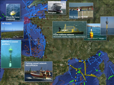
In this framework, four main operational platforms are identified to be integrated to the CORIOLIS coastal/regional domain :
- eulerian platforms :
- MAREL systems : MOLIT, Mesurho, MAREL-Carnot, MAREL-Iroise
- SMATCH buoys : RESCO and Island networks
- sea level data from REFMAR and RONIM networks
- HF SOMLIT stations (in the RESOMAR network) (not fully included in the Coriolis convention but fully interfaced with Coriolis)
- Meteo-France moorings (Brittany, Gascogne)
- High Frequency radars
- measurements from vessels of opportunity :
- FerryBox : RV Armorique, RV Pont Aven
- RECOPESCA network
- coastal profilers : ARVOR-C and ARVOR-Cm
- drifting systems : surface drifters and sub-surface Gliders
CORIOLIS Contribution
CORIOLIS aims to provide a national coordination for permanent in-situ coastal and regional observations of interest to both research and operational oceanography. This coastal extension of CORIOLIS activities is structuring within the European community of JERICO, EuroGOOS and MyOcean projects.
The various observing systems for coastal measurements are deployed and maintained by the CORIOLIS partners : IFREMER, SHOM, Meteo-France, and the biological station of Roscoff.
Real-time data from eulerian platforms are collected in the CORIOLIS database, qualified by the SCOOP software and distributed to the CDOCO (Data Center for Operational Coastal Oceanography). R&D activities for coastal CORIOLIS applications are organized through 4 thematics:
- evolution of real-time and delayed mode procedures for the data control
- conception of new historical databases and climatologies
- observation network optimisation
- new instruments and new sensors
MORE INFORMATIONS
- JERICO project
- RECOPESCA network
- NKE instrumentation

