Overview
An international surface drifter network
Created in 1985, the Data Buoy Cooperation Panel (DBCP) is an international programme which aims to coordinate the use of autonomous data buoys to observe atmosphere and ocean conditions for forecasting and research in ocean areas where few measurements are taken. The primary objective of the DBCP is to maintain and coordinate all components of the global network of over 1250 drifting buoys and 400 moored buoys, which provides measurements such as atmospheric pressure, sea-surface temperature and salinity, surface current velocity, air temperature, air humidity and wind speed and direction.
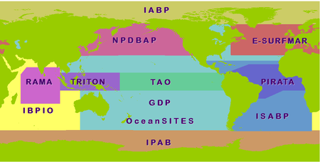
Much of the work achieved by the DBCP is through action groups for global or regional coordination. Each group maintains an observational buoy program that supplies data for operational and research purposes. Since 1987, EGOS then E-SURFMAR act as DBCP regional action group for the North Atlantic.
E-SURFMAR is the EIG EUMETNET Operational Service for surface marine observations. EIG EUMETNET is the grouping of European Meteorological Services. E-SURFMAR main objective is to coordinate, optimise and progressively integrate European sea surface observation activities in order to improve numerical weather prediction. These activities include data buoys and Voluntary Observing Ships (VOS).
E-SURFMAR has been managed by Meteo-France since its creation in 2003.
Figure : DBCP action groups ©jcommops
CORIOLIS Contribution
- BUOYS DEPLOYMENTS :
Each year, the Centre de Météorologie Marine of Météo-France (CNRM/CMM) manage the deployment of about 150 buoys in average : 110 in the North-Atlantic and in the Arctic for E-SURFMAR activities, 10 in the Tropical Atlantic and 30 in the Indian Ocean for Meteo-France contribution to IBPIO, regional action group pf DBCP for the Indian Ocean. Most of those drifters take part of the Global Drifter Program (GDP) from DBCP organization.
- DATA PROCESSING AND DISTRIBUTION :
Data from surface drifters are sent in real-time onto the GTS (Global Telecommunication System of WMO). In France :
-
- CNRM/CMM provides, in near real-time, surface currents deduced from drifting buoy GTS data and monitoring tools (graphs, statistics...) which allows data buoy and VOS operators to control the platforms for which they are responsible. Know more here
- CORIOLIS Data Centre provides access to most archived GTS buoy data.
- Copernicus in situ service is funding the C-RAID global reprocessing of drifting buoys data
In 2012, more than 2 millions of surface currents data measured by more than 1750 surface drifters have been collected by the Coriolis Data Center.
MAPS
Figure : DBCP Map from last month. GTS data as received by Meteo-France ©JCOMMOPS
Figure : the latest 30 days of data acquired by the drifter from DBCP network and available from the Coriolis Argo GDAC (Global Data Center) © CORIOLIS
MORE INFORMATIONS
- E-SURFMAR homepage
- DBCP homepage
- Global Drifter Program
- surface drifters technology

